|
|

楼主 |
发表于 2014-10-31 18:09:12
|
显示全部楼层
请大家把贴出来的信息认真读两遍,明天9:40am马蹄湾渡船码头售票处见,可以早到不要迟到,特别是坐公车的朋友请弄清坐车站点不要错过9点锺Downtown出发的#257公车
已报名:
lulululu
michaelqian
Steven Wang
杏儿
white snow
麦芒
more information:
we might take this route:
There are a number of routes to get to the Mt. Elphinstone Summit trail. This one is probably the most direct route and starts in Langdale. However, it is also the most physically challenging as you are starting at sea level which means a total elevation gain of about 4100 feet.
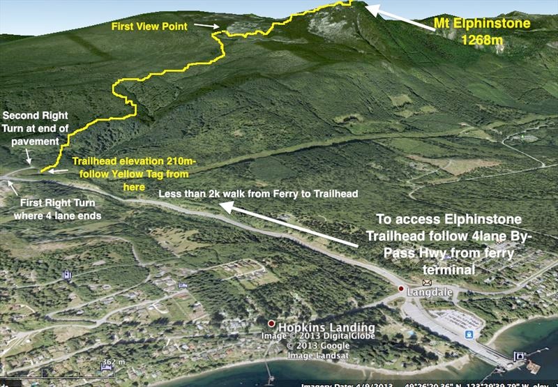
I specifically showed this one with instructions for those who arrive by ferry and wish to walk off to do the hike. For those who live in the area you can access the White trail from the lower end of Sprockids.
After disembarking the ferry turn right at the light. This is the Port Mellon Hwy.
Walk a short distance and take a left on Wharf Rd. Go to the end and you will see a trail continues on into the bush.
Follow this trail. You will see trails that go off to the right and left, but you stay on the main one. You will pass a small rock quarry with pond on the left. If you have dogs don't let them drink this water as I understand there is arsenic that has leached into this water.
Keep following this trail and when you come to the power lines you will be going to the left still following the trail which parallels the power line for a short way.
After another five minutes or so you will come to a bridge over Langdale Creek. Once you reach the other side you are into the Sprockids bike park and the trail is officially called Lunge.
Follow Lunge for a few minutes up hill until it comes to an intersection. You are going right here and will follow the White trail until you reach the Elphinstone Summit trail. The time to reach the Summit trail will likely be between 20-40 minutes depending on your speed.
When you start on the White trail you will notice it is marked with multiple coloured diamonds, but as you go you will eventually be left with the just the white.
If you look at the map you will see that you actually come to a trail called Pressure Drop and then another called Wildman. I would bypass these trails and take the next trail to the right which is marked with a yellow marker and a sign that says Mt. Elphinstone Summit trail.
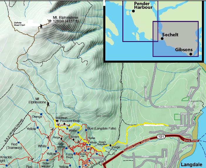
This shows the route in yellow and in relation to the other trail in Sprockids Bike Park.
a higher resolution pdf version:
http://www.sunshine-coast-trails ... phinstone-route.pdf
The first half of Mount Elphinstone Summit trail is a moderate climb. You will hear Langdale Creek down below for quite a way and will eventually cross it again at about the half way mark (you crossed it earlier on just before entering Sprockids Bike Park).
10 or 15 minutes past the creek crossing you will come to a viewpoint. This is about 3100 feet. 1000 feet to go!
There is a stretch of the trail that goes in and out of boggy, wet terrain. Considering I was hiking it in August, I think earlier in the year this would be a very, very wet slog. The mosquitoes and little black flies were bad.
A little further on you will come to an intersection with a trail going off to the left. It is marked To Dakota Creek Roads. Note: This trail takes you out to an old, deactivated logging road that joins up with another old road and if you stay left you eventually come out to a different branch of B & K. It is about a 1/2 hour to an hour to hike out to the B & K.
You would be able to get fairly close to the trail by atv, but not all the way as there are some very deep gullies and the road is partially washed out in places. I did notice some tire marks to within about a 10 minute walk to where the trail comes out to the road. The trail is marked on the road on some logs with a sign that says To Mount Elphinstone trails and this trail is marked with red markers. This has actually become my favourite route in and out.
Anyway, at this junction keep right if you want to get to the top of the mountain. DO NOT GO LEFT. This part of the hike is fairly steep, but only takes about 15 minutes or so.
You will come to a bluff area with views, but the trail continues on to another bluff area marked with a flag. This is still not the top. Keep following the trail until you get to the tippy top of the mountain where you will see a cell tower and wooden helicopter pad.
MT. ELPHINSTONE HIKING TRAILS
A trail to the summit of Mt Elphinstone (1266m., 4153 ft.) above the Langdale ferry landing on the Sunshine Coast was opened in 2010. The main trailhead may be reached from the ferry by following traffic straight up the divided highway known as the Bypass. At the top of the hill, where traffic turns left down to the town of Gibsons, turn right instead. The road promptly ends in a “T” junction with both arms gated. The trailhead and parking is before the gate on the right.
The Elpinstone Summit Trail is defined by yellow markers, and runs almost entirely through mature forests until the open summit ridge with good views. For safety reasons, the trailhead sign suggest eight hours return, but most parties in summer will find six sufficient. Two hours should be added, however, if walking up from the ferry. For those wishing to come across as a foot passenger (recommended on summer weekends) and have little appetite for trudging 3 km. up the open, busy Bypass Highway, a bypass-bypass route has been established with pink markers. From the entrance to the ferry lot, walk 200 meters north up the coastal highway to Warf Road. The route starts from the top of this and joins the summit trail just above the main trailhead....
 |
|


 IP卡
IP卡 狗仔卡
狗仔卡 发表于 2014-10-31 10:31:53
 提升卡
提升卡 置顶卡
置顶卡 沉默卡
沉默卡 喧嚣卡
喧嚣卡 变色卡
变色卡 显身卡
显身卡 发表于 2014-10-31 10:55:56