开启辅助访问 切换到宽版

北美户外俱乐部

 找回密码
 注册
搜索
热搜: 活动 交友
查看: 1908|回复: 45

Climbing Emblem Peaks of the Western U.S. (2022 trip)

[复制链接]
扫一扫,手机访问本帖
发表于 2022-7-30 06:00:36 | 显示全部楼层 |阅读模式
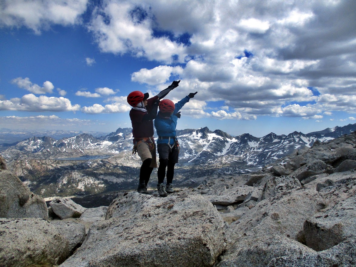
Two of us went on a 36 days trip to the U.S. with six main alpine objectives, mainly to finish all of the Western U.S. State High Points. Although the original plan looked unrealistic in the beginning because all these require proper weather and climbing conditions, we have successfully climbed all peaks on our list and also summitted some more, as a bonus.

THE LIST
Mount Thielsen (2,799 m), Oregon "..a dramatic horn-shaped peak located just north of Crater Lake.."
Mount Lyell (3,999 m), the highest mountain peak in Yosemite National Park, California
Boundary Peak (4,007 m), the highest mountain peak in the state of Nevada
Wheeler Peak (4,013 m), the highest mountain peak in the U.S. state of New Mexico
Gannett Peak (4,209 m), the highest mountain peak in the U.S. state of Wyoming
Granite Peak (3,904 m), the highest mountain peak in the U.S. state of Montana

Extra Emblem Peaks
Glacier Peak        3,206m        USA-WA
Banner Peak        3,943m        USA-CA
Mount Ritter        4,006m        USA-CA
Mount Saint Helens        2,540m        USA-WA

Minor Peaks
Chicken Ledge        2,763m                USA-OR
Donohue Peak        3,665m                USA-CA
Mount Andrea Lawrence        3,731m        USA-CA
Simpson Peak        3,955m                USA-NM
Old Mike Peak        3,997m                USA-NM
Mount Walter        4,003m                USA-NM
Mount Si        1,274m                USA-WA

When: 2022.06.24 - 2022.07.29 (36 days)
Distance driven: 11,780kms


On this trip, we have finally completed all western U.S. State Highest Peaks (WA, OR, CA, AZ, NV, UT, NM, CO, WY, MT, ID)


 楼主| 发表于 2022-8-1 08:26:09 | 显示全部楼层
2022.06.24 Day 1/36
Driving en route to our first objective, Mount Thielsen in Oregon.

Crossing the U.S. border was the fastest we ever remember, no lineup, the cop just scanned our passports and let us go. No Covid19 questions asked. Returning back home a month later through the same border (Peace Arch) will be exactly the opposite (the worst we've ever had), the description of which I will omit in this trip report because it is not even funny anymore.

First gas station stop.


Typical average rest area. We love it.


Our preferred food, instant noodles with salsa for dinner.


 楼主| 发表于 2022-8-1 11:14:24 | 显示全部楼层
2022.06.25 Day 2/36

Climbing our first objective, Mount Thielsen, Oregon.


"..Mount Thielsen is a dramatic horn-shaped peak located just north of Crater Lake. The peak rises abruptly from its surroundings to a very distinct spire. Its north and east faces are most impressive, towering 2200 feet upward in a near vertical fashion..."
https://www.summitpost.org/mount-thielsen/150419


As the bivouac's article puts it, "..The south ridge is the standard route. It requires some exposed Class 4.." and as such qualifies for our confident comfort range of alpine climbing: not too boring, not too hard.


Gear: 2x 30m 8.0 climbing ropes for rappel (one pitch).


First view of Thielsen


Approaching the "chimney" part


The crux


On top


Rappel station at the top looked good and a better option than downclimbing.


California Climbers' Salute at Chicken Ledge - the first flat space good for CCS.


 楼主| 发表于 2022-8-2 06:17:59 | 显示全部楼层
2022.06.26 Day 3/36
En route to our 2nd objective, Mount Lyell, the highest peak in Yosemite National Park, CA


We had good weather all 36 days.
\

Passing by.


37C outside

 楼主| 发表于 2022-8-2 08:59:50 | 显示全部楼层
2022.06.27 Day 4/36

Mount Lyell, Yosemite National Park, Califormia
Day 1/4,  hike in, 17.5 km

Entering Yosemite National Park, CA


Selfie at Rangers' Station


Backpacking Permit


Packing our gear


View from the trail


Our trail is both Pacific Crest Trail and John Muir Trail.  


Meeting the first thru-hiker.


Clear water of Lyell Fork creek.


We take break every 40 minutes


All thru hikers loose weight. This one is already down by 15lbs.


First view of our objective, Mount Lyell


On this trip, our tent, which is not even 4-season, will take hard rain without leaking and survive 100km/h winds.


Dinner is getting ready.


Despite horrible stories about mosquitoes in this area, we had none of them (well, almost).


Cold!!


 楼主| 发表于 2022-8-2 11:43:29 | 显示全部楼层
2022.06.28 Day 5/36

Mount Lyell, Yosemite National Park, Califormia
Day 2/4,  Summit Day

Round trip: 12.7 km

Mt. Lyell is the highest peak in Yosemite National Park. .a very popular destination despite its long distance from the nearest trailhead. It is easily recognizable from the summit of most peaks in Yosemite, thanks to the prominent Lyell Glacier on its northern flank, the largest in the park. ..is also the highest point in Tuolumne county, one of the more difficult of the 58 California county highpoints


Our gear set for steep snow


Approach


Off trail from here


First snow caps


On a climbing day, we stop for a break every 45 minutes


More snow caps


We prepared for climbing steep snow, but instead it was steep rock


Summit!


This peak has been on our climbing list for quite a few years.


Summit register always gives confidence you are on the true summit.


Hero picture, why not, we deserved it.


Some views from the top, on which we unlikely will ever step again.


Banner Peak (3,945m) - little we knew we will climb it on this trip!


Mount Ritter (4,008m) - we will climb this one too! (and we didn't know it yet)


Selfie at the top of Mt. Lyell. We were the only party on the summit that day (  which feels nice ) .


More views


This peak we also planned to climb same day, but oh-well, how often ambitions over-exceed our resourses. Until next time, perhaps.


California Climbers' Salute in California...


Photo by Vera, who often snaps good pics, and which are later very hard to get from her (or lost altogether).


Class 4 moves here and exposed. Thanks to stable dry rock. Usually such sections will have rap stations, alas, none here.


More pics by Vera


Finally can sit and relax, the rest is easy.


Snow caps again


Aren't they beautiful?!


Our camp near Lyell Fork creek. Pretty private spot despite foot traffic - this is both PCT amd JMT trail, some go south to Mt. Whitney (220 miles away), others are en route to Canada (N miles north).


 楼主| 发表于 2022-8-3 07:10:46 | 显示全部楼层
2022.06.29 Day 6/36

Mount Lyell, Yosemite National Park, Califormia
Day 3/4,  Bonus Day

Our backpacking permit was good for yet another night, with our objective (Mt. Lyell) being completed, so we thought to do an easy hike to a couple of peaks here before moving our camp to another area. The peaks turned out to be more involving than we expected, and took entire day, so we camped here without moving.

Round trip: 16 km

Peaks: Donohue (3,665m) and Andrea Lawerence (3,730m)

Hard to beleive, but this area is at 3,100m above sea level, almost the  height of Mt. Baker WA!


Scenic Donohue Pass


With solo thru hiker from Montreal


None of the peaks seen here have names.


Dashing across running creeks like that requires skills and determination.


Our 45-minutes break at Donohue Pass (PCT and JMT)


Clear water of Yosemite


Four thru hikers, one of whom already lost 25 lb. Mount Lyell that we climbed yesterday rises at the back.


Yet another 75(!) y.o. thru hiker.


Another shot at Lyell (L) Maclure(R)


Our objective, Donohue Peak


Who was here?!


Attractive looking peaks, Banner (most left) and Ritter next to it. On this trip, we will climb them too, but we don't know it yet!


Can't help but stop to soak in the moment.


Shot by Vera


Boulders, stable and dry though.


At the top of of Donohue Peak


Banner - Ritter - Davis


Summit register at Donohue Peak was not expected, but was there.


Thousand Island lake is a very popular destination for backpackers.


Selfie with Banner and Ritter behind


California Climbers' Salute at the Donohue Peak with Lyell at the back


 楼主| 发表于 2022-8-3 10:18:08 | 显示全部楼层
2022.06.29 Day 6/36 contd.

Shortly after I convinced Vera that I am sure "my route" to Mount Andrea Lawrence is good, we got this unexpected snow chute. Oops. Luckily our emergency short static cord was enough for belay - the chute is steep and long.


Shot by Vera


Slabby


Hero shot on the false summit of Mount Andrea Lawrence - GPS pointed here, but the higher point is ~100m away.


Selfie with Lyell behind


CCS at Andrea Lawrence. Thousand Island Lake at the back.


On the way back, we dropped down to the base to avoid the chute.


Passing by snow caps.


Banner Peak


With Banner - Ritter on left and Lyell at right.


Scenic  Donohue Pass


Back at our to camp for the last, 3rd night.


 楼主| 发表于 2022-8-3 15:29:48 | 显示全部楼层
2022.06.30 Day 7/36

Mount Lyell Day 4/4
Hike out, 17.5km

Gear prepared to pack


Shaking clean before next use


Let's go!


Last view of Mt. Lyell from PCT trail


Lyell Fork creek


Trout


We drink it from the creek untreated


 楼主| 发表于 2022-8-4 05:03:30 | 显示全部楼层
2022.06.30 Day 7/36

Driving to Nevada, our next destination is Boundary Peak (4,007m), the highest in the state.

PHOTO: Boundary Peak is seen at a distance. Getting on this unpaved road was a bad choice, that only pure luck saved us from major trouble.


Boundary Peak (4,007m) NV


In a very short while, the road got rough so we decided to make u-turn. Slowly backing off on reverse, I heard a weird noise and the car won't move anymore. It was stuck. Well, only if we read carefully trip reports from the past about cars getting stuck on this road, where there is no signal, and a nearest tow company is 70 miles away, and the charge is $100s per hour, then.. Nevertheless the mountain gods were lenient and spared us from disaster. We were back on the paved surface soon after.

PHOTO: This rock was loose enough to remove using ice axes. Could be much much worse.


As we drove away from the infamous road, woving never return, we were discussing how to climb Boundary (it was our trip's major objective as a U.S. TOP 50 High Point) - rent a car, go to a nearest town and hire a driver with a high clearance truck, park our car and hike the road. None of these ideas was attractive. We were running out of gas too. In Nevada, gas stations are spare and often you will see a  road sign saying "No gas next 100 miles". Besides, it was getting late, so when we reached the first town, as expected, the only gas station there was already closed. How to get gas when a gas station is closed, not to mention learning how to get to the trailhead of Boundary in a compact car, seemed out of question, so we just prepared to give up, but...

..to be continued..


 楼主| 发表于 2022-8-4 09:54:05 | 显示全部楼层
2022.07.01 Day 8/36

Boundary Peak (4,007m), the highest natural point in Nevada

Round trip: 18.9 km

Sunrise


Vera is amazingly good at extracting right information from the vast flood of everything (mostly junk) on the Internet. I am bored and quickly fall asleep reading someone's stories. So, when browsing yet another post she casually mentioned "the actual turn-off to gravel road is at these coordinates" I knew that it was exactly the thing we needed.


On the "right road". Boundary Peak is seen at skyline. Route finding and driving to the trailhead of Boundary was the actual crux of this peak. We almost didn't make it.


One of the very few flat spots


Our today's destination


"The col"


The air is getting thinner; the summit is above 4,000m.


Closer shot at Boundary Peak


As always, we stop every 45 minutes for a break.


Summit!


This peak had been sitting on our climbing wish list for a long long time.


California Climbers' Salute at Nevada's highest point.


The peak behind is higher, but it is in Califronia


Someone came with two(!) babies at the top. The parents are cautious but ambitious high-pointers. No Denali on the plan, but who knows. "..You can't control your dreams, for they come to you without asking.."


Good-bye, Boundary!


The local humor. The owner of this gas station shop (Linda) was the key to our success. Of course, without Vera's determination we would have never met her.


 楼主| 发表于 2022-8-5 04:35:19 | 显示全部楼层
2022.07.02 Day 9/36


In Nevada, en route to New Mexico.

 楼主| 发表于 2022-8-5 04:45:56 | 显示全部楼层
2022.07.03 Day 10/36

Early breakfast in Quality Inn, Winslow, AZ en route to New Mexico.


"..make today worth it.."


In Nevada, speed limit often 80mph (130 kmh)


 楼主| 发表于 2022-8-5 05:33:46 | 显示全部楼层
2022.07.04 Day 11/36
Wheeler Peak (4,013m), New MexicoRound trip: 14.7km

At 13,161 feet above sea level, Wheeler Peak is the highest mountain in New Mexico, which ranks as the 8th state in order of elevation.

https://www.summitpost.org/page/150429


"..The standard route on Wheeler Peak is along the north ridge. The route starts at the parking lot for Taos Ski Valley, and proceeds east along an old road to a broad saddle at Bull-of-the-Woods Meadow. .."


California Climbers' Salute at the summit of Wheeler Peak


These flowers live at 4,000m above sea level


Bonus nearby: Simpson Peak (3,995m)


CCS on Simpson, NM with Wheeler Peak behind


Bonus #2: Old Mike Peak (3,997m)


CCS at Old Mike, elevation only ~400m lower than Rainier, but what a difference.


Wheeler Peak became our 11th U.S. State High Point.


Wheeler Peak from Old Mike


Bonus Peak #4 - Mt. Walter (4,003m), our 30th mountain above 4,000m


Wheeler Peak at the back


Alpine meadow


 楼主| 发表于 2022-8-5 09:57:00 | 显示全部楼层
2022.07.05 Day 12/36
En route to Wyoming

In the U.S. , there is no standard for rest areas - some have private rooms with free WiFi, some are super simple. You never know what kind will be in the next state. This one was better than on average. Colorado.


Passing by rural farm road. American flag, of course.


 楼主| 发表于 2022-8-5 11:21:12 | 显示全部楼层
2022 JUL 6-10

Gannet Peak (4,210m), the highest mountain peak in the U.S. state of Wyoming

Nights: 4 (5 days)
Round trip: 93.1 km

Any summit attempt of Gannett Peak requires a wide variety of mountaineering skills. Considered as one of the most difficult state highpoints, the only other state highpoints that either rival or exceed its technical difficulty are Denali (Alaska), Mount Rainier (Washington), and Granite Peak (Montana). It is debatable whether or not the latter two are actually more difficult than Gannett Peak, depending on experience, skills, weather, and conditions.
https://www.summitpost.org/mountain/150362

To be continued..
 楼主| 发表于 2022-8-6 06:11:36 | 显示全部楼层
2022 JUL 6 Day 13/36

Gannet Peak WY, Day 1/5
Hike in, 19.2 km


Dubois, WY. After reading many stories about how hard the trip is and so many people hired guides, and even though we were sceptical we need it, we tried to hire porters (which we have never done before). Luck was on our side - we never found them - they were all booked months before or went out of business. For it would have been be a huge disappointment about unnecessary waste of time and money - we carried everything including food, climbing and camping gear. Alpine walk technique and nothing more made it an enjoyable hike in.


This flower bed will travel in our car, which is already 100% full of gear and supplies, for another three weeks. And it will survive.


Trailhead registration.


First 40- minutes break. Today's travel distance will be 19.2km.


We will have to cross half a dozen of creeks like this, twice. Only one will have a bridge.


Peculiar feature of the area is that rains are often very short, they only last 10-15 minutes. We use tent fly for cover - Vera's good idea.


Arrow pass


Another rain


And now blue sky back again.


Crossing this one was easy.


Fording Double Lake creek. Shorty after reaching our bivy site and pitching the tent, a hard rain will begin and last through the night.


 楼主| 发表于 2022-8-7 06:06:57 | 显示全部楼层
2022 JUL-7 Day 14/36

Gannet Peak WY, Day 2/5
Moved camp, another 23 km.

Camp 1 at Star Lake. Last night just after we finished pitching the tent, it started raining hard through the night, but the tent survived without leaking.


Hanging food cache for the return last day.


Intense Downs Fork creek.


This new bridge over Downs Fork creek is 1km up the stream and that many people don't know about.


Alpine meadow of Wyoming.


The very first view of our objective - Gannett Peak, 4,209m high. Looking at that snow ridge I hoped we wouldn't have to climb it, alas that was exactly what we would do tomorrow: 1 km of soft, steep and exposed snow, the top is at the very right side and the route enters the ridge on left.


Dinwoody Creek


Bobs Towers don't get climbed often.


Unnamed peaks


From a descedning group, we heard that there was a helicopter rescue a day ago - one of them fell from the rocks and was injured.


Crossing Klondike Creek. Falling into it with full expedtion backpack is not a good idea.


At the end of Day 2 (42km total) we felt very good and lucky that "hiring porters" idea had not materialized. Carry expedition backpack on a good trail was not super hard: alpine walk technique and rest stops every 40 minutes is all you need.


Looking for flat spot for tent


Some snow - even that late in the day, was hard.


Our home for the next two nights. That feeling taking off the boots after walking 23km with backpack full of gear.


 楼主| 发表于 2022-8-7 19:42:11 | 显示全部楼层
2022 JUL-8 Day 15/36

Gannet Peak WY, Day 3/5
Summit day, 8.2 km.


Sunrise at the Base Camp of Gannet Peak


Ready to go!


Alpen glow at Gooseneck Pinnacle


This terrain looks easy in daylight, but walking here at 1a.m. is super slow - a fall, an injury and a rescue occured here 2 days ago.

"..on July 6, officials from neighboring Fremont County contacted Sublette County Dispatch to assist an injured climber who had fallen into a field of boulders and become stranded on the east side of Gannett Peak. According to the SAR team, the man was located at 10,200 feet elevation, prompting Fremont County to request the other agency’s assistance. While waiting for the rescue team, fellow hikers tended to the man’s injuries and were able to staunch the bleeding.
Top SAR members arrived and aided the man downstream, where the helicopter was waiting. He was flown to the Lander Hospital, where he received medical care..."


Summit ridge and Gannet Peak under clear blue skies.


Dinwoody Glacier


Gannet Glacier


Getting on rocks. Looks easy, but a fatal fall occured here in 2021.


Frequent transition from rock to snow and back.


Gooseneck Pinnacle


Carefull climbing - another fall and a helicopter rescue occured here 10 days after us.


The summit!


This huge summit register was buried under ice, no wonder there were no records of 2022.


Views from the summit.


Exposed ridge, 1km like that


Summit is seen on left


Protect early, protect often.


With summit ridge above


 楼主| 发表于 2022-8-10 05:35:05 | 显示全部楼层
2022 JUL-9 Day 16/36

Gannet Peak WY, Day 4/5
High Camp -> Star Lake (23.3km)

Klondike Creek


您需要登录后才可以回帖 登录 | 注册

本版积分规则


小黑屋|Archiver|手机版|北美户外俱乐部

GMT-8, 2024-4-23 15:15 , Processed in 0.080079 second(s), 5 queries , File On.

快速回复 返回顶部 返回列表