扫一扫,手机访问本帖 
|
Lorna Lake
Access: This area can be accessed by various means. One can come in via the Warner Pass trail, Lorna Pass or Elbow Pass. also can come in via Relay Creek trail to Big Creek trail. Well worth it!
Trip Reports I found online:
1.Lorna Lake: Jewel of the Southern Chilcotins by Claudia
*****************************************************
August 3-6/2006
Although we believe in earning a great campsite by foot, we opted to fly in/out of Lorna Lake (at the last minute) due to time constraints. And besides, this opened up many possibilities for bringing ‘extras’ – like running shoes, fresh fruit ...and beer! With no reservations made, Tyax Air squeezed us in for a flight on Aug 3 eve – one hour after we arrived! Winds were calm so we were able to land.
Our objective was revisit some cool mountaineering routes near to this awesome lake. We scored the best campsite at the head of the lake which is known for its blustery nature – the mosquitoes were kept at bay which was a huge bonus.


Day 1: Trail Ridge (which is just E of Lorna Lake) via Lorna Pass. The morning started off with some showers (oh no!) but then it soon cleared (whew!). Just after breakfast we heard some rocks rolling down the nearby steep scree slopes and were surprised to see a grizzly sidehilling very close by! ee-gads! grizzlies, already? Off scampered the grizzly over Lorna Pass, which is where we needed to go. Didn’t see him though as we ascended Trail Ridge and did the rollercoaster ride to an awesome viewpoint over upper Lizard Ck & Big Ck valleys. Looking down at the milky turquoise waters of Lorna Lake was sweet. We took a down (scree) escalator as a short cut to bring us right back to our camp.


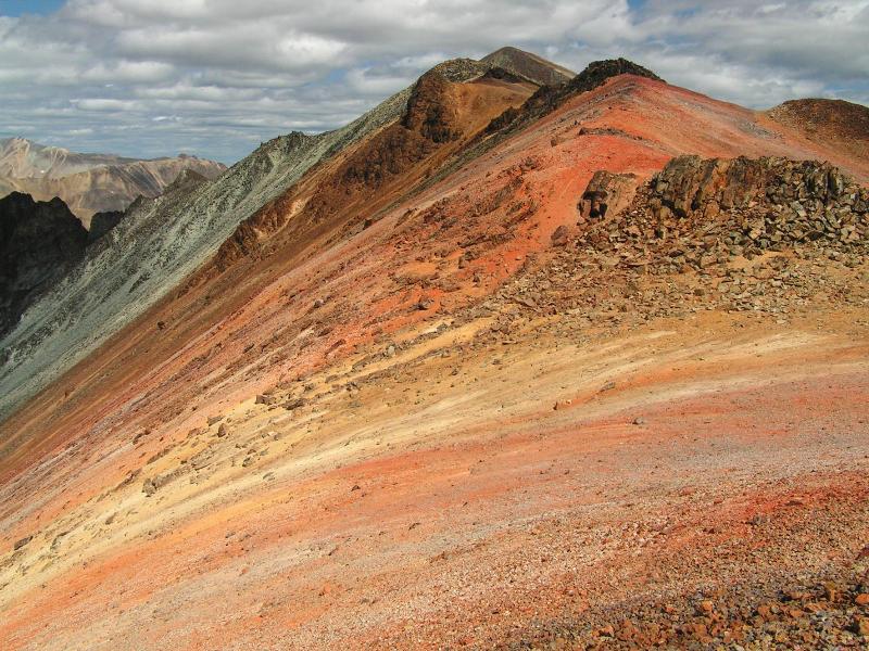
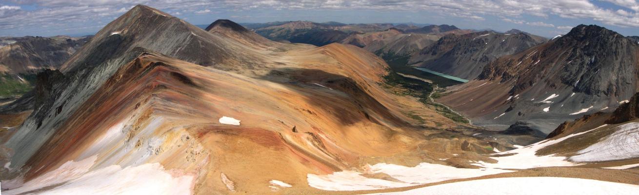
Day 2: Warner Ridge via Sluice Ck. This was a new route for us to access Warner Ridge – thought we’d give it a try. Dashing through the forest to nearby Sluice Ck and accompanying it to its headwaters turned into a very pleasant route. Our calling out for bears brought out a sow moose and calf who probably couldn’t believe the silly sounds they were hearing. The many high alpine glaciers and rainbow colored ridges greeted us. Up the scree to connect into Warner Ridge then south for more up and down. The views and geologic colors here are superb.

Day 3: Early morning chat by sat phone indicated that if we didn’t leave today we wouldn’t likely be picked up until Wed. So we reluctantly pulled the plug and were whisked back to Tyaughton Lake. Only 2 days at Lorna – but what a 2 days!

A reply I got:
you have to get yourself to Tyax Lodge on Tyaughton Lake in Gold Bridge. To get there you take the same Hurley Road as to get to Semaphore Lakes. You just keep going. If you'd like detailed information check out some of the early photos in my flickr set
http://www.flickr.com/photos/scrambler27/sets/771559/
More relevant info- They limit the number of people allowed into Lorna Lake. I think there is a 12 person per day maximum. You are best to make reservations for the flight in although as indicated, it may not be necessary and even if you have reservations, if the conditions are not good, they won't fly in. The flights go early in the morning or late in the afternoon due to wind conditions so it's best to get there a day early and camp nearby so you can get to the lodge for the early flights in. I think the cost is ~$70 bucks a person but I'm not sure. We got a group rate for the 12 of us and were lucky to all get in the same morning. It was debatable. 4 people can go in per flight. Hope this helps some.
**********************************************
2.In a Big Country: Return to Big Creek by Stewart Douglas
**********************************************
August 1, 2005 (4 days) Calculated Length: 41 km
Participants: Stew, Maximus, Robbie, Simi, J-Crew.
Equipment: 3 season tent, hiking boots (approach shoes would work too) and good attitude.
Difficulty: Hiking up to 15 km a day, easy scrambling and mild elevation gain. Good routefinding skills may be required if one loses the trail.
Abstract: In August 2005 we returned to the Southern Chilcotins to try access Lorna Lake via Big Creek. We were successful and were rewarded with one of the nicest hikes I have ever been on.

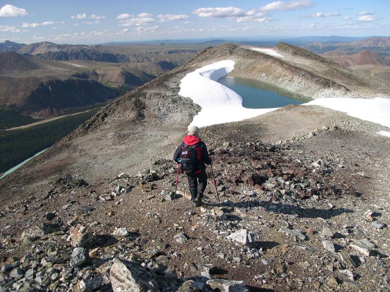
The northern end of Lorna Lake with the northern most peak of the Warner ridge chain
After going into the southern Chilcotins for the first time a couple of years ago, I knew I would be back. I found the topography totally amazing and the lack of other people hiking around very special. After not making it to Lorna Lake in my last trip to Big Creek I found the perfect excuse to make another trip into the area. This time I brought a few armchair warriors who like whiskey, so I knew it would be a fun one (albeit a backpack trip where I might be doing a lot of waiting).
We drove into Relay Creek and I was surprised that the road seemed in better condition than the previous time. The drive went well until Jesse popped a flat in his Land Cruiser. With the mechanism totally rusted, it took 2 hours to get the spare out (that was only half inflated). But we arrived at the trailhead with a couple hours of daylight left. We followed the same route as before over Relay Pass and down into the Graveyard Creek Gang Ranch cabin. The cabin had deteriorated some since my last visit but was still very habitable (but none of us wanted to touch the full bottle of Crown Royal left there). We had big campfire and I was stupid enough to sample a little too much of the rye whiskey.
We woke to broken skies and for me a wicked headache. Having a quick bite we broke camp and started southward towards Lorna Lake. Now, the last time I was on this trail I took the first left and ended up bushwhacking all the way to Elbow Pass. Not this time. We stayed right and soon passed over Big Creek. The trail contoured the western side of the valley with gentle climbs and descents. Very quickly we passed over Big Creek. Soon we began dropping evlevation and began to contour Tosh Creek as we moved through it's valley. Some gain of elevation and we found ourselves at Teco Lake. This pretty lake would have made for an excellent campsite but we had Lorna on our minds and after a short break we pushed on.
As we hiked I was very happy that we were actually on the trail. Having to bushwhack the last time really wasn’t fun. It would have been tolerable except that we had spent way too much time looking for a trail that didn’t exist. After Teco Lake, we contoured SW into the Grant Creek drainage gaining elevation. We came out to a sweet meadow overlooking Big Creek. The trail became indistinct here and there were some grumbles from the crew as to what we should do. Most figured we could see where we wanted to go, so let’s just make a bee line for it and we would pick up the trail again sometime (hopefully). We began to drop down to Grant Creek and before long had picked up the trail again. We had fun crossing of Grant Creek over a nice sized log (but there were a couple among us who made the crossing look like a ladder traverse above Everest base camp). Soon we came out to Big Creek and started heading south down it'swestern shore.
Within an hour we had arrived at Lorna Lake. We were blown away by the beauty of the lake. Sitting nestled between big peaks, the turquoise waters looked very inviting. Well, it would have been inviting if the winds weren’t gusting to 60 km. At 6300 feet strong winds really seem to cool things down quick. We thought about making camp right by the lake, but with no windbreaks around we decided to find shelter in the trees.
We went to bed early and rose the next day to gathering clouds. We set off towards Lorna Pass, and began to feel the burn in the legs and chest. Just as we reached the pass, the rains began. We put on the rainwear and watched the rain squalls move up the Tyaughton valley. We had planned to hit valley bottom then travel by trail over to Little Paradise valley and back to Relay Creek. But with the rains falling we decided to stay high and travel over to Elbow Pass, then take the high trail over to Tyoax Pass. We got ourselves pretty wet but the high trail to Tyoax pass is absolutely wicked! It travels at about 6800 feet and snakes its way around valleys, peaks and passes. Even the steady rainfall couldn’t dampen the fun of this trail. What was even more amazing was that we came to an area at 6800 feet where the rocks had fossilized remains of shells from an ancient seabed imbedded in them.
After Tyoax Pass we dropped down to Little Paradise Creek and headed back to Relay Creek. Once there we set up camp even though we were less than 3 km from the vehicles (I guess we didn’t want the fun to end). The next day dawned nice and sunny and even though we were worried about the condition of the road (see muddy, slippery mess) we made it out without too much problems. That is until Jesse’s Land Cruiser got another flat tire.
Nothing but fun in the Southern Chilcotins!
**********************************************
Map info:
Southern Chilcotin Mountains Trail Map – GPS Based –
ISBN 0-9738679-0-6
 |
|


 IP卡
IP卡 狗仔卡
狗仔卡 发表于 2006-8-8 11:08:41
 提升卡
提升卡 置顶卡
置顶卡 沉默卡
沉默卡 喧嚣卡
喧嚣卡 变色卡
变色卡 显身卡
显身卡 发表于 2006-8-11 12:44:47
 发表于 2006-8-11 14:34:03