开启辅助访问 切换到宽版

北美户外俱乐部

 找回密码
 注册
搜索
热搜: 活动 交友
查看: 19308|回复: 19

Brew Hut

[复制链接]
扫一扫,手机访问本帖
发表于 2005-12-4 17:57:53 | 显示全部楼层 |阅读模式


这是我想带队overnight snowshoeing的地方之一。一些相关资料:

Range Hierarchy: Pacific Cordillera / Coast Mountains / Pacific Ranges / Squamish-Cheakamus Divide
Region Hierarchy: BC Coast South / Coast-Chilcotin / Pemberton Icecap

November 26, 2005   (1 days)
Participants: Greg Stoltmann, Robin Tivy, Betsy Waddington, Steve Grant, Linda Billy

Abstract: A useful description of how to find and follow the new trail to the new Brew Hut.

Late Friday night, we decided to pay a visit to the new VOC hut near Mount Brew. Various Bivouac/VOC members had constructed a new trail, so we had to check it out. I still remember constructing the first Brew Hut in 1982, (which was crushed by snow creep in the first winter). And I had been to the second hut several times, so it only seemed right that I should visit the third hut. As you may know, the Mount Brew area is a fairly gentle plateau like ridge that sticks eastward from the Mount Fee and Cypress Peak area, which is the end of the "Powder Cap" traverse.

I want to make this description as useful as possible, so I'll put in all the driving instructions and road references.

We drove up highway 99 from Vancouver and turned west onto the Chance Creek FSR. This road was completely clear of snow, and we were soon at the junction where we turned north on the Roe Creek Road. We hit shallow snow at 2200' which never got more than 15 cm deep, and was no problem for Greg's luxurious 4WD Isuzu Trooper. After a while we came to the intersection with a branch road going east. We were confused thinking it might be the Branch 200 that we wanted. But a quick check with the GPS told us it was not the correct road. After another 5-10 minutes of so we reached the proper intersection with Branch 200 at 936m (3070 feet).

There was one set of tire tracks ahead of us. We drove for a short distance up the steep Branch 200. This section had fairly deep cross ditches, and we dragged the trailer hitch on every crossing. Soon we reached the impassable ditch which was mentioned in the previous road bulletins. Here we found the Jeep Cherokee already parked, and we parked just below it.

There wasn't enough snow to start skiing right away, so we put our skis on our packs and hiked up the road, past the first switchback, and then reached the trailhead, marked by dozens of yellow ribbons. (which prompted some singing of "Tie a yellow ribbon round the old oak tree..." from the time of Richard Nixon.

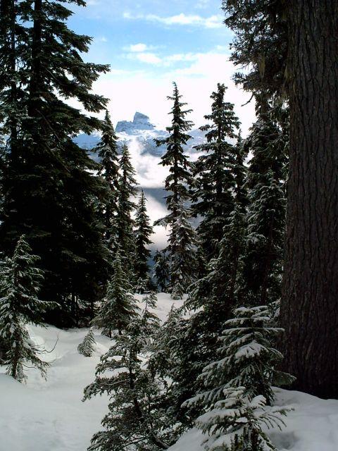
The trail heads back eastward through the clearcut until it reaches the dark old growth. The clearcut is now grown in with cedar trees about 4 m high. Once in the old growth, it was occasionally difficult to find the next yellow ribbon, provoking an observation that yellow is not the ultimate color. The snow was packed like concrete. Only occasionally would you break through. Soon we were at the first creek, where the trail abruptly turns 90 degrees and goes up the fall line. Greg and I momentarily lost the trail here. But soon enough we found it and arrived below the prominent cliff bands. Here we followed the trail eastward again, till it wrapped around the cliffs and went north, up the big creek drainage. This is the big creek on the 1:50,000 that is due south of Brew Lake. The trail just follows the west side of this creek. In this section of trail, I had a bit more problem punching through, which prompted me to put my skis on and off several times. We soon met the two BCMC members who came in the Jeep. They had MSR snowshoes, which were ideal for this terrain, costing about 100-200 dollars.

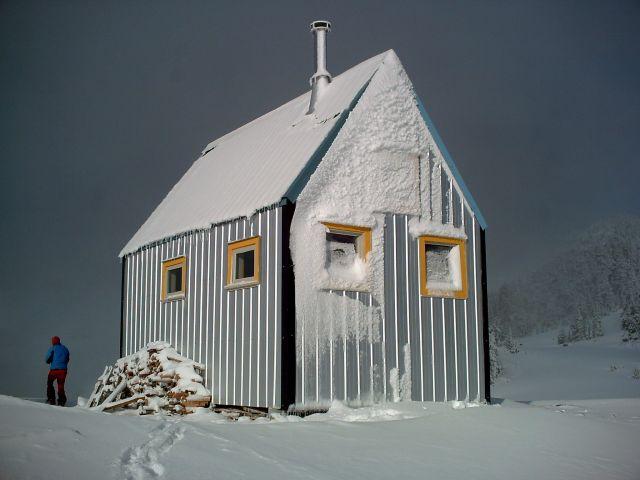
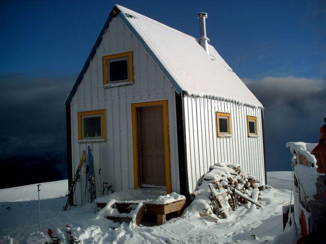
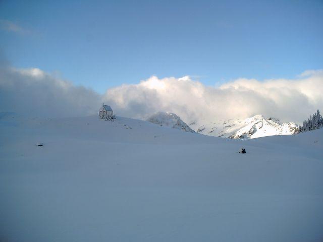
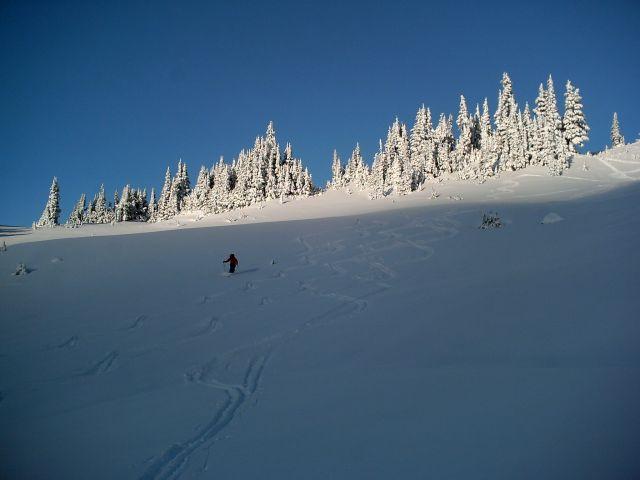
Eventually the trail leaves the creek, and goes west up a steep little slope and emerges above treeline. Everybody then put their skis on, and soon we were zooming along. It was so foggy you couldn't see much, but there was an increasingly deep cover of fresh powder. These meadows are immediately south of Brew Lake. From here the route went on the west side of the lake, and heads west. The final climb to the cabin is up a short hill and through a notch, and then the cabin is immediately east of us.

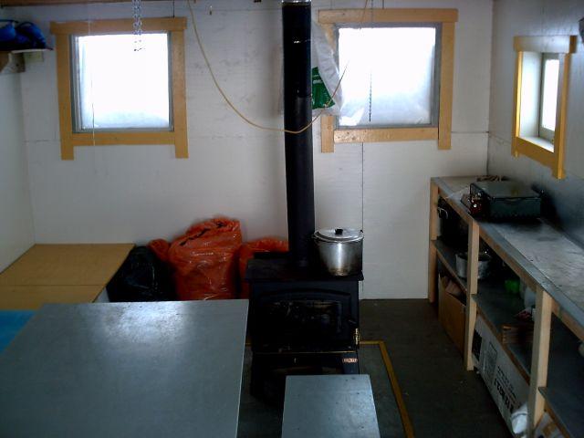
After dutifully reading and signing the log book and inspecting the library, we skied a few short slopes beside the cabin, then headed down. The skiing was really great, with 15 cm of fresh powder covering a bombproof base layer. Very soon we were back in the trees, where everybody took their skis off. The walking was very good, and we were back at the car well before dark.

Associated Road/Trail Bulletins
Chance Creek FSR
Roe Creek Branch R200
Roe Creek road

Waypoints: Geo-WGS84   UTM-WGS84   UTM-NAD27c   Help
50:00.5-123:12.1=Park (3250 feet) washout
50:00.4-123:11.6=Trail starts from logging spur (Yellow Ribbons)
50:00.4-123:11.3=First small creek (trail turns up fall line) 3600'
50:00.5-123:11.1=Below Rock Face 3780'
50:00.5-123:11.0=Trail stays below cliffs until in water course 3850'
50:00.5-123:10.9=1st small pond, trail in open 4020'
50:00.9-123:10.8=Clearing, continuing below cliff band 4210'
50:00.9-123:10.8=Below bluff #3
50:01.0-123:10.8=bottom of Talus slope
50:01.1-123:10.8=start of meadow system
50:01.2-123:10.8=more meadows
50:01.2-123:10.9=notch joins from west
50:01.3-123:10.9=cross small creek to East side?
50:01.5-123:11.0=More meadows
50:01.7-123:11.0=End of yellow flagging at SW shore of Brew Lake
50:02:24-123:11:33=Brew Hut

===========================

more Brew Hut info by Rick Raymond
November 26, 2005   (2 days)
Abstract: Added waypoints

Silvia and I headed up the Roe Creek Ski route to the Brew hut for an overnight trip. Since we had never been up there before, we followed the waypoints from the VOC Wiki website. Robin and his group passed us on the trail and since Robin has already posted a great trip report I wont say much here. After the yellow flagging ended, we had the tracks from Robin's group to follow. The route they chose worked out very well so I added some waypoints to the Wiki page waypoints to make a more complete set for traveling in poor visibility conditions.

Waypoints: Geo-WGS84   UTM-WGS84   UTM-NAD27c   Help
50.00741-123.19485=Trailhead on R200, start of yellow flags
50.00694-123.19333=Enter Old Growth Forest
50.00666-123.18882=Just below creek crossing
50.00788-123.18341=In bowl
50.00848-123.18281=In bowl #2
50.00891-123.18238=top of bowl
50.01105-123.18138=end of a small draw below bluff #2
50.01314-123.17988=Reenter forest after going below bluff #2
50.01437-123.18047=Below bluff #3
50.01630-123.18055=bottom of Talus slope
50.01893-123.18041=start of meadow system
50.01928-123.18069=more meadows
50.01999-123.18171=notch joins from west
50.02109-123.18210=cross small creek to East side?
50.02450-123.18302=More meadows
50.02789-123.18358=End of yellow flagging at SW shore of Brew Lake
50.02995-123.18750=Left toward hut
50.03302-123.19217=Turn right
50.03395-123.19169=Turn toward hut
50.03670-123.19318=Around hill toward notch
50.03956-123.19256=Notch turn right to hut
50.04002-123.19125=Brew Hut
发表于 2005-12-4 18:08:29 | 显示全部楼层
看了资料,觉得这地方不错,而且有朋友刚去过,看到那个小木屋位置不错,选址安全且方便,真是选地方的高人!

希望LuLu选个天气好的日子,可以非常的享受那里! :lol:
 楼主| 发表于 2005-12-4 18:11:24 | 显示全部楼层
Brew Hut:


inside main floor of Brew Hut


sleeping area on second floor


wood stove
 楼主| 发表于 2005-12-4 19:10:33 | 显示全部楼层
发表于 2005-12-4 21:12:46 | 显示全部楼层
要去要去, lulu赶快召集啊, 又可以overnight啦, 还可以烧火,好玩!
发表于 2005-12-4 21:36:07 | 显示全部楼层
小归懂的享受,你想,一天辛劳下来,拖把椅子坐在火炉前,一杯热咖啡,拿本《103》或国家地理这类不动脑筋的书,有一搭没一搭翻翻...... ,对比窗外漫天大雪:lol:  :lol:
 楼主| 发表于 2005-12-5 14:24:16 | 显示全部楼层
上次我带队走的是summer route,这是当时Alex的GPS记录的信息,我们只到了B点,雪深坡陡,到了talus后已经看不到任何标记,当时我们朝着湖的方向找路走,我猜想我们最后一小段走的是和trail平行的路线。两个local  hiker手持GPS跟着我们的足迹最后也因时间问题不得不放弃。冬季走这条夏季路线怕有雪崩的危险,我们下次要走安全的冬季路线。

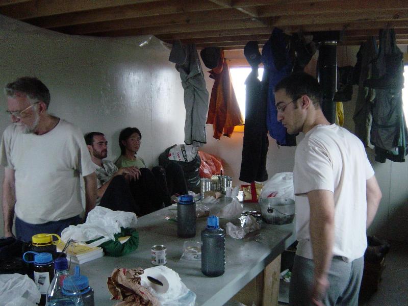
发表于 2005-12-5 21:32:39 | 显示全部楼层
lulululu
上次我带队走的是summer route,这是当时Alex的GPS记录的信息,我们只到了B点,雪深坡陡,到了talus后已经看不到任何标记,当时我们朝着湖的方向找路走,我猜想我们最后一小段走的是和trail平行的路线。两个local  hiker手持GPS跟着我们的足迹最后也因时间问题不得不放弃。冬季走这条夏季路线怕有雪崩的危险,我们下次要走安全的冬季路线。


好好好!应该走冬季的线路。
发表于 2005-12-7 02:06:02 | 显示全部楼层
googoo
好好好!应该走冬季的线路。


Lulululu:

It is a very challenging route.  A question.

Can we drive up the ROE creek (the dark line on the map)?
Driving on snow is not fun.  Do we need snow chain in
addition to snow tire.
发表于 2005-12-7 02:14:58 | 显示全部楼层
归去来兮
要去要去, lulu赶快召集啊, 又可以overnight啦, 还可以烧火,好玩!


好!!

烧火还要烧酒烧肉

少一不行。(我出烧酒,你出烧肉 - 我的愛人不吃肉)怎樣? :lol:  :lol:
 楼主| 发表于 2005-12-7 08:38:08 | 显示全部楼层
ALEXYIM
[quote]googoo
好好好!应该走冬季的线路。


Lulululu:

It is a very challenging route.  A question.

Can we drive up the ROE creek (the dark line on the map)?
Driving on snow is not fun.  Do we need snow chain in
addition to snow tire.[/quote]

here is the info provided by a UBC-VOC member:
Have a look at the 1:50000 NTS topo map or the BC basemap website (maps.gov.bc.ca -> BC basemap), they both indicate the position of the roads, although the R-200 spur that the trail leaves from is not shown on the NTS map. I don't know exactly how good the flagging is over the whole route, so you'd best be ready to do some navigating on your own; I'd suggest bringing along the trail description and the GPS waypoints from the website. Good luck with your adventure, and please post your findings either here, or on the VOC wiki page for the trail.

The start of the road is about 1km south of the rubble creek bridge on highway 99. It's the only road with a bridge over the cheakamus river. There are a lot of branches, here's what I can remember from the 2 times I've been up there (mileages are estimates):

1. cross the bridge, the tracks and turn left, and follow the road up a hill. This part is called Chance Creek FSR
2. at 1.5km is the base area for the cat skiing operation at a switchback, go left.
3. Pass a couple of minor spurs on the right. I don't think they go anywhere really. There is a major junction at about 3km, this is the start of Roe Creek FSR. Take the right fork. All distances beyond this point are measure from here and there are a new set of km markers for this road that start at this junction.
4. +0.3km A minor branch off roe creek goes, right, ignore it. This was blocked by a fallen log on feb 6th.
5. +0.5km A more serious branch road goes left. Go right (up a hill?). Stay right from here until the bridge over roe creek at about km 3.
6. just past the bridge turn left. The right fork is R-100 and it ends after only 0.5km.
7. continue straight through a muddy log sort
8. At 3.8km or so is the end of 2wd and a good place to park. 4x4HC begins if it isn't too snowed in to drive. The road get pretty gnarly and bushy above here, and there isn't a good place to turn around for another 1.5km.
9. At km 5.3 is a branch on the right (R-200). Follow this one steeply uphill to the trailhead, which is just above the first switchback, about 1km up R-200.


It seems that we need to walk 2.5KM to reach the trailhead of the winter route  if we don't have a 4WD (or we can rent one?)

I suggest the drivers at least use all season tires(or better use snow tires/prepare chains) when going up local mountains during winter times.

I'll check for a road update before we go. We'll parepare to walk on FSR.
 楼主| 发表于 2005-12-7 08:52:00 | 显示全部楼层
more road info from bivouac:


Roe Creek road :

Access To: East side of Tricouni, north ridge of Cypress Peak, and west/south side of Mount Brew.

Condition: 2wd to 7km from highway 99

General Route: Runs up along the east side of Roe Creek to the very last fork in Roe Creek. Note that this is about 2km farther than the road is shown on the 1:50000. The end point is just north of the latitude of Cypress Peak.

How To Find: To get to the start of the road, go up Highway 99, turn off onto the Chance Creek road, then after several km, turn onto the Roe Creek road. At first, the Roe Creek road goes gradually down to a bridge. Once across the bridge you are on the north side of Roe Creek. From here the road climbs steadily. It is always on the east side of the creek. As you drive along, you first come to the "false" junction running off to the east (Br100?), and then later, the true Branch 200 junction. The road is a steady climb, which could be done by any vehicle, until you get to the 14 waterbars and big washout near the end.

Waypoints: Geo-WGS84   UTM-WGS84   UTM-NAD27c   Help
49:58.1-123:10.7=Jct Chance Creek FSR
49:59.4-123:11.4=Roe West
49:59.5-123:11.4=Roe Creek bridge and spur R100 on right
50:0.0-123:11.7=860E386N
50:0.0-123:11.8=859E387N
50:00.6-123:12.3=spur R200 on right 936m (3070 feet)
50:01.5-123:13.1=spur
50:01.9-123:13.2=First washout (requires high clearance 4WD
50:01.9-123:13.2=Second washout, End of driveable road
50:02.2-123:13.4=840E427N, end of the road
Bulletins:
2005.12.05 Jos Van der Burg Driveable to near 7 km: We were able to drive to near 7 km up the road, about 20 min. from the end on foot. Had to carry the skis for a couple hundred meters through the last of the forest and across Roe creek.From there smooth skiing to Cypress Peak. 6.5 Hour round trip. *1

2005.11.26 Robin Tivy

Road has 10 cm snow: We drove the road in Greg's Isuzu Trooper, as far as the turnoff to R200 at 3070 feet (936m). There was a thin snow cover, but any 4WD could make it. See Trip Report *3

2005.11.20 Matt Gunn Drove to Roe Creek Bridge: There is snow on the Roe Creek Road starting just past the junction with Chance Creek Road. a couple 4wd vehicles drove to the Roe Creek Bridge at 2260 ft. We could have drive another kilometer with chains.


Roe Creek Branch R200

Calculated Length:2 km   RoadType:Spur   Elevation Gain:900-1200m

Access To: Brew Lake, Brew Mountain, Brew Hut

Condition: According to Western Forest Products, road is ok (some small alder, still driveable 4x4 HC if you want) to switchback #2, totally overgrown beyond.

Waypoints: Geo-WGS84   UTM-WGS84   UTM-NAD27c   Help
50:0:37.5-123:12:19.2=Junction with Roe Creek Mainline 936m (3070 feet)
50:0:25.7-123:11:40.4=Switchback #1
50:0:26.7-123:11:41.5=Start of Flagged route to Brew Lake
50:0:49.9-123:11:55.5=Switchback #2
50:0:40.2-123:11:42.0=End of Road (BC Basemap)

Bulletins

2005.11.26 Robin Tivy Road driveable to washout at 3250': We were able to drive all the way to the washout at 3250 feet in Greg's 4WD Isuzu Trooper. There was very little snow on road, but the waterbar ditches would stop a 2WD.
 楼主| 发表于 2005-12-7 09:07:55 | 显示全部楼层
more info from CT:

Originally posted by sgRant
We were up this route on Saturday, and I wanted to say the new route is longer, but safer than the old one.  Thanks to the extensive brush clearing, it also means less thrashing.  Most of the new route is a very gentle climb, except for a couple of short steep climbs in the woods.  Without gps waypoints, don't expect to be able to find the cabin in a whiteout.  

Summer use of the route through the woods will need some fine-tuning to get around wet areas, but once the snow fills in, this will be an excellent ski route.  Yesterday, the skiing wasn't worth it until the subaline, but it was excellent from there.  

The cabin itself is a very impressive job.  Great work, VOC!  Ran into Roland today on Seymore, and talked with him about it.


Originally posted by sgRant
[quote]Originally posted by sandy
How long to get in?


We couldn't drive to where the trail leaves BR200 Roe Creek spur logging roa, since there's a more or less impassable washout about .5km before the trailhead.  Our hiking was slowed by the track, which was mostly atop lumpy frozen snow with occasional trapdoor plunges for amusement.  Searching around for the route a couple of times used up perhaps 10 minutes.  I didn't take any breaks along the way but wasn't pushing the pace.  With all those provisos (and oldfart hasbeen status), it was about 2hr. 40 min. from washout to cabin.  The last of our party arrived within 45 minutes.  It took about the same time to come out due to the poor footing, which was worse going downhill.  A couple going in with overnight packs took over 4hr.  

Approaching via Roe Creek in winters past has required skiing from as low as the highway, so it will take longer as the road gets snowed in.  If you are delayed, there are two cabins along the logging road: one just above the Roe Creek /Chance Creek fork, and the other a few minutes off the road at Genter's Lake on the original Tricouni trail.

I'd never been to the new cabin, but I had a rough idea of where it must be.  So from the subalpine I set my own course even if the faint tracks from the previous weekend went elsewhere.  But I always came across those tracks again, then presto, the cabin popped into view just seconds away.  Unlike the route to the site of the previous cabin, which is not far east of the new one, you bypass Brew Lake on the west rather than cross the east side of the lake.

Btw, the cabin looks smaller in the pictures than it is.  According to Roland it's 12'x20', with room upstairs for 13 to sleep. The attention to detail in the construction is something to behold.  A ramped threshold so you can easily sweep snow and dirt outside!  Genius.  The cabin has great views.  It's especially good to see a cabin that's intended to be accessed on foot rather than by helicopter.  The policy of not encouraging summer use makes sense, so I'll resist the compulsion to take my loppers to the trail.

Has anyone heard of snowmobiles making it to the Brew cabin(s)?  We saw a snowmobile track up BR200 on Saturday, perhaps looking for a weakness in the defenses.

[/quote]

more pics:


发表于 2005-12-7 10:48:21 | 显示全部楼层
漂亮的地方,但一定要找个晴天去,且注意有否雪崩。
 楼主| 发表于 2005-12-7 11:05:16 | 显示全部楼层
忘了登陆了,上面是我,lulululu
 楼主| 发表于 2005-12-7 16:35:42 | 显示全部楼层
just got a reply from UBC-VOCer:

It's 2.5km from the end of 2wd to the trailhead. The 2.5km is measured by GPS, so it's pretty accurate. Based on current reports, you should be able to get close to that point provided you don't get stopped by a slippery hill. If it snows down to a low elevation, you are looking at about 7.5km of road skiing / walking to get to the trailhead from the snowcat shed.
 楼主| 发表于 2005-12-7 17:12:53 | 显示全部楼层
 楼主| 发表于 2005-12-12 22:20:14 | 显示全部楼层
转最新的TR & pics(上周日/12/11):

http://www.leelau.net/2005/brew111205/brew111205.htm
 楼主| 发表于 2005-12-12 22:24:18 | 显示全部楼层


发表于 2005-12-13 16:18:34 | 显示全部楼层
看上去不错,什么去呢?
您需要登录后才可以回帖 登录 | 注册

本版积分规则


小黑屋|Archiver|手机版|北美户外俱乐部

GMT-8, 2024-5-17 00:20 , Processed in 0.061920 second(s), 7 queries , File On.

快速回复 返回顶部 返回列表